More Stories
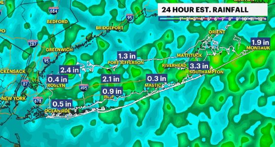
WHAT'S NEW: Say goodbye to summer and hello to fall today as a cold front has moved through the area, bringing rain, breezy winds and a drop in temperatures.
WHAT'S NEXT: The rain has wrapped up but we’ll deal with the effects of this cold front passage. Autumn starts tonight, at 9:04, with breezy to windy conditions and cooler temperatures! Conditions will improve through the weekend, both with diminishing winds and rising temps but we’ll also be watching for our next rain chance arriving Sunday night into Monday.
TROPICS: FIONA is a CAT 4 hurricane with 130 mph winds. (This has not changed in the past 2 days). It’s path takes it just to the west of Bermuda. It’ll move towards southeast Canada over the next several days but kick up rough waves for LI.
GASTON is a tropical storm that poses no threat to land as it churns in the north Atlantic Ocean, heading towards the Azores.
There are 3 other disturbances we are watching in the ocean, with one likely to become HERMINE in a day or two, in the Caribbean Sea.
Storm Watch Team Meteorologist Addison Green says a new season of fall will bring cooler temperatures.
FORCAST:
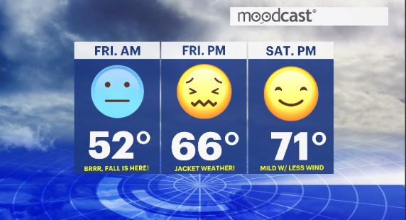
OVERNIGHT: Decreasing clouds with breezy winds that will gusts, at times, of 20-30 mph. Lows: upper 40s to low 50s.
*Autumn arrives officially at 9:04 PM*

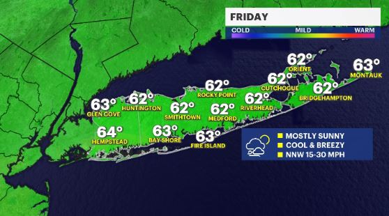
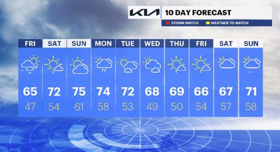
FRIDAY: Northwest winds, that will be breezy to windy, at 10-30 mph. That wind will make the air feel a little colder, especially for the morning hours. Mostly sunny skies and very dry air will be in place for the afternoon with the winds lingering. Highs: mid 60s. Lows: upper 40s to low 50s.
SATURDAY: *PICK OF THE WEEK* - Staying dry, with milder temps and sunny skies with a light breeze. Great Fall Weather! Highs: low to mid 70s. Lows: mid 50s.
SUNDAY: Mostly sunny to partly cloudy, mild temps and with a light breeze at times for the afternoon. Showers will arrive after sunset, through the overnight hours into Monday. Highs: mid 70s. Lows: upper 50s to low 60s.
NEXT WEEK: Shower activity is around early on in the week with drier and clearer skies to follow, as temps cool down from the mid 70s to upper 60s.
More from News 12
0:38

Patchogue man accused of kidnapping 4-year-old from laundromat
2:25

Less chilly this afternoon across Long Island, warm weather by mid-week
1:53

'She's got just an incredible fight to her.' Hockey for Harper fundraiser supports 2-year-old cancer patient
0:21

Remsenburg road rage suspect accused of threatening driver with crowbar
0:53

‘No Kings’ rallies held across Long Island
0:55
