More Stories
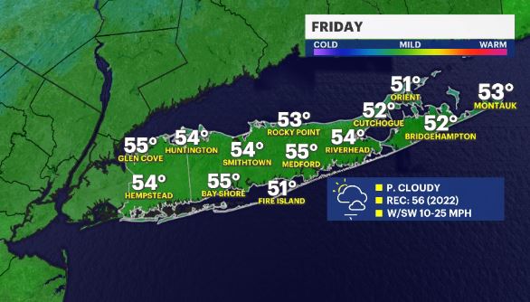
WHAT'S NEW: Another warm day is in sight for Friday, with a chance of hitting a record high. (56 - 2022). After that, we'll cool down heading into Saturday.
WHAT'S NEXT: A large storm will try to move up the East Coast on Sunday, giving us a chance for rain Sunday afternoon/evening. It'll pull away Monday midday.
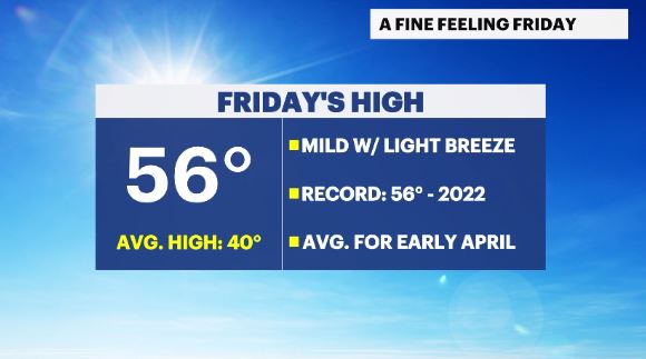
News 12 Storm Watch Meteorologist Addison Green says there will be potentially record-breaking temperatures for the end of the workweek ahead of cooler air.
OVERNIGHT: Clouds fade along with rain chances. Temps stay mild along with breezy winds. Lows: upper 40s to low 50s.
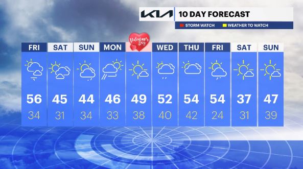
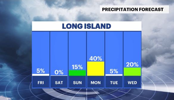
FRIDAY: Mostly sunny to partly cloudy. Temps will be very mild. RECORD: 56 (2022). Highs: low to mid 50s. Lows: low 30s.
SATURDAY: A mix of sun and clouds. Highs: mid 40s. Lows: upper 20s to low 30s.
SUNDAY: Mostly cloudy to cloudy with rain shower chances for the second half of the day. Highs: low to mid 40s. Lows: mid 30s.
MONDAY: Early showers to fairer skies later on along with breezy winds. Highs: mid 40s. Lows: low 30s.
TUESDAY: Valentine's Day – Mostly sunny and mild. Highs: upper 40s to low 50s. Lows: upper 30s.
WEDNESDAY: Partly cloudy with a chance for rain showers. Highs: upper 40s to low 50s. Lows: upper 30s to low 40s.
THURSDAY: Partly cloudy with scattered showers & above average temperatures. Highs: low to mid 50s. Lows: low 40s.
FRIDAY: Mild with showers and breezy winds. Highs: low to mid 50s. Lows: mid 20s.
SATURDAY: Mostly sunny and colder. Highs: mid 30s. Lows: upper 20s to low 30s.
SUNDAY: Mostly sunny to partly cloudy with milder temps. Highs: mid 40s. Lows: upper 30s.
More from News 12
1:11

Toddler fatally struck by vehicle in Mount Sinai
2:02

Cold weekend on Long Island; arctic blast arrives next week
1:15

Carle Place restaurant reopens after $60K kitchen equipment theft
0:17

Carle Place man seriously injured in single-car Elwood crash
0:49

Remembering Liam Gleason: Funeral held for late Siena University men's lacrosse coach
2:18
