WEATHER TO WATCH: Remnants of Ian to bring heavy rain threat for the weekend
Storm Watch Team Meteorologist Addison Green says Ian's remnants could cause the possibility for flooding this weekend
•
Sep 30, 2022, 10:00 AM
•
Updated 951 days ago
Share:
More Stories

News 12 weather blog
2ds ago
Power center: Electric outage resources
5ds ago1:29

Rainy weather expected to impact viewing of Eta Aquarids meteor shower
6ds ago1:43

Long Islanders bask in warmer weather on Easter weekend
19ds ago1:43

Partial solar eclipse to take place Saturday ahead of sunrise
42ds ago1:24

April weather outlook: Will we trend typical or warmer?
45ds agoNews 12 weather blog
2ds agoPower center: Electric outage resources
5ds ago1:29
Rainy weather expected to impact viewing of Eta Aquarids meteor shower
6ds ago1:43
Long Islanders bask in warmer weather on Easter weekend
19ds ago1:43
Partial solar eclipse to take place Saturday ahead of sunrise
42ds ago1:24
April weather outlook: Will we trend typical or warmer?
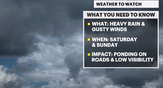
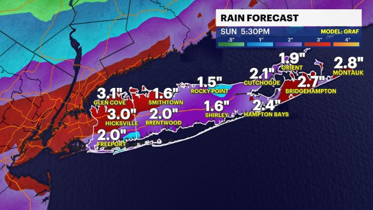
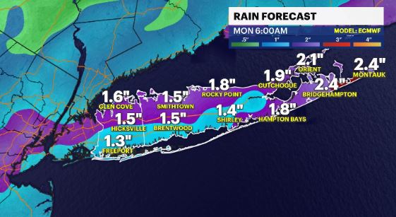
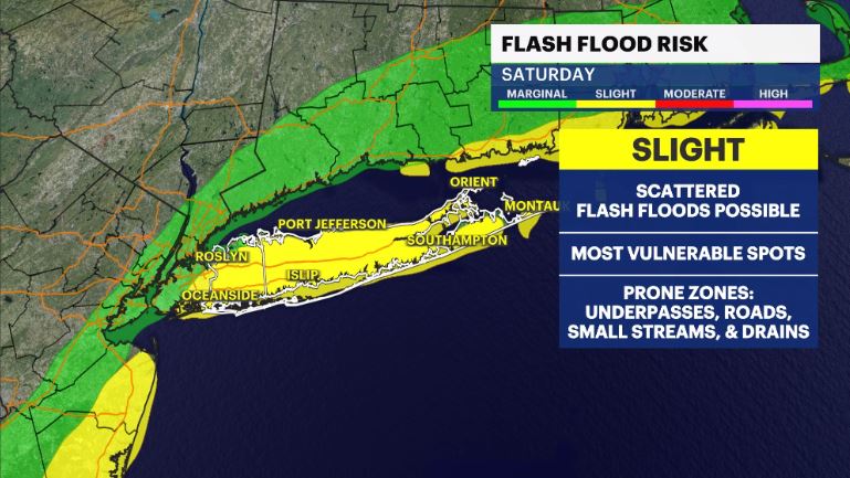
45ds agoWHAT'S NEW: The potential for flash flooding is slowly increasing for Saturday with Ian's tropical moisture pushing this way. The first half of the day will absolutely be a soaker.
WHAT'S NEXT: Going through the weekend, expect some tropical downpours and on/off scattered showers to come along with breezy to gusty winds. Next week looks & feels better (mostly) until we get to Friday afternoon.
TROPICS:
IAN - labeled as no longer a hurricane at 5 pm, as it made landfall after 2 p.m. near Georgetown, SC with 85 mph winds and then proceeded to transition and loose it's tropical characteristics. Either way, it will still be moving further inland, soaking the Carolinas and that rain moves up towards us this weekend.
There is another disturbance that has a medium, 60%, chance of becoming a named storm in the next 5 days. It is out in the Eastern Atlantic Ocean and poses us no threat.
Storm Watch Team Meteorologist Addison Green says Ian's remnants could cause the possibility for flooding this weekend.
FORECAST:
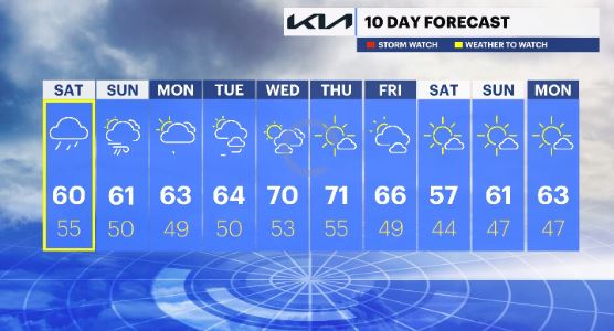
OVERNIGHT: Mainly cloudy with rain showers to move in around 3 AM and become more steadier heading towards daybreak. Lows: mid 50s.
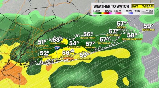
SATURDAY: Weather To Watch – Expect tropical downpours for the first half of the day with on/off scattered showers and pockets of drizzle. Winds will be steady, out of the northeast, at 10-25 mph. Highs: upper 50s to 60. Lows: mid 50s.
SUNDAY: Possible Weather To Watch (for wind) – Scattered rain showers will come and go through the day, especially midday. Winds will pick up out of the northeast, at 15-30 mph. Highs: upper 50s to low 60s. Lows: upper 40s to low 50s.
MONDAY: Breezy with scattered showers, especially for the morning hours. Highs: mid 60s. Lows: upper 40s to low 50s.
TUESDAY: Breezy at times with a mix of sun and clouds. Highs: mid 60s. Lows: low 50s.
WEDNESDAY: Partly cloudy with less wind. Highs: upper 60s to 70. Lows: low 50s.
THURSDAY: *Pick of the week* Mostly sunny, mild and pleasant. Highs: low 70s. Lows: mid 50s.
FRIDAY: Partly cloudy with winds picking up as a cold front passes by in the afternoon. Highs: mid 60s. Lows: upper 40s.
NEXT WEEKEND: Breezy, dry and very cool under mostly sunny to clear skies. Highs: upper 50s to low 60s. Lows: mid to upper 40s.
More from News 12
2:17

Elwood school district asking voters to approve budget that pierces tax cap to avoid cuts
2:19

STORM WATCH: Rainy Friday before comfortable, sunny skies arrive
0:31

Officials: Man accused of stabbing Suffolk police officer faces additional multiple charges for damaging cars
0:48

Stamp out Hunger Food Drive taking place across Long Island Saturday
0:32

Police: 2 men accused of scamming woman out of $387,000 in Greenvale
0:46
