More Stories
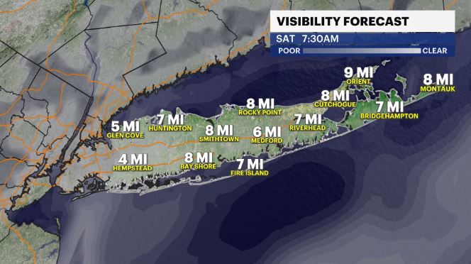
WHAT'S NEW: Warmth continues to move in across Long Island, but so does moisture. We have the potential for more patchy to dense fog to develop overnight into Saturday morning & Sunday morning.
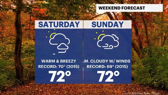
WHAT'S NEXT: A WARM weekend is coming our way with the potential for daytime highs to set records across Long Island.
TROPICS:
There are 3 disturbances being monitored by the National Hurricane Center.
LISA – The system is a tropical depression but was a category 1 hurricane before it made landfall in Belize Thursday evening. It has moved across Southern Mexico, and has come out into the Southwest Gulf of Mexico, where it will eventually fade away over the weekend.
A s second system is a tropical wave in the North Caribbean Sea. It has a moderate (40%) chance of development in the next 5 days. It's moisture could come towards the Southeast US by midweek, next week.
A third system is a tropical wave in the Central Atlantic Ocean. It has a low (10%) chance of development in the next 5 days. It will pose no threat to anyone.
Storm Watch Team Meteorologist Addison Green says record high temperatures could hit this weekend.
FORECAST:
OVERNIGHT: Increasing cloud cover with some patchy to dense fog, especially by the coastal areas by daybreak. Lows: mid to upper 50s.
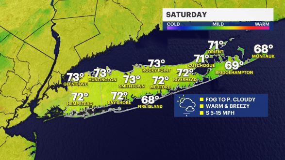
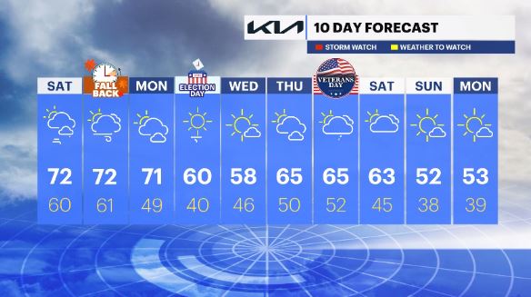
SATURDAY: A mix of sun and clouds, with breezy winds and a touch of some humidity in the air. Highs: upper 60s to low 70s. Lows: upper 50s to low 60s. Record High: 70 (2015). Forecast for Islip: 72.
SUNDAY: Mostly cloudy & breezy at times. Highs: upper 60s to low 70s. Lows: upper 50s to low 60s. Record High: 69 (2015). Forecast for Islip: 72.
***DAYLIGHT SAVING TIME ENDS on Sunday. Turn the clocks back before you go to bed, Saturday night. Sunday, at 2 a.m. we "fall back" to 1 a.m. and gain an hour of sleep but lose an hour of daylight.
We go from SUNRISE: 7:27 A.M. & SUNSET 5:44 P.M. to SUNRISE at 6:29 A.M. & SUNSET at 4:43 P.M. ***
MONDAY: Partly cloudy to mostly sunny, still rather mild to warm. Highs: mid 60s to low 70s. Low: upper 40s. Record High: (). Forecast for Islip: 71.
TUESDAY: ELECTION DAY – Mostly sunny, cooler, drier and breezy. Highs: low 60s. Lows: low 40s
WEDNESDAY: Mostly sunny, cool and crisp with temps around seasonable levels for this time of year. Highs: Upper 50s. Lows: mid 40s.
THURSDAY: Partly cloudy & mild. Highs: mid 60s. Lows upper 40s to low 50s.
FRIDAY: VETERANS DAY – Mostly cloudy with isolated showers. Highs: mid 60s. Lows low 50s.
NEXT WEEKEND: Mostly cloudy to mostly sunny with temps cooling down. Highs: low 60s to low 50s. Lows: mid 40s to upper 30s.

More from News 12
1:25

Church choir director accused of sexually abusing teen girl in East Meadow
1:43

Stray Sunday showers, heavy rain tonight

Enhanced role for immigration officers at US airports as shutdown frustrates travels and screeners

Police video of Justin Timberlake’s 2024 drunken driving arrest released
1:49

Rockville Centre rallies to support Nassau Police Officer Patricia Espinosa’s family
0:29
