More Stories
WHAT'S NEW: A weak cold front is on the way, to pass over Long Island on Wednesday, but it'll just bring around a slightly more cooler air mass, as our temps go down a few degrees for Thursday and Friday.
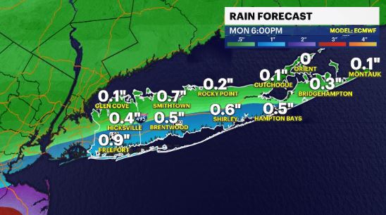
WHAT'S NEXT: All eyes will be on IAN and where that system will go next after landfall. We could see some of that tropical moisture come up this way by Sunday, and hang around for a few days, bringing some much needed rain.
TROPICS:
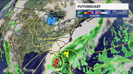
Ian is a major hurricane, roughly 200 miles away from the southwest coast of Florida. Alerts are up for much of Florida and up the coast into the Carolinas. Landfall is likely sometime Wednesday afternoon, between Tampa and Fort Myers, as a category 4 (winds 130+ MPH)
There is other other disturbance we are watching in the ocean, that has a modest (60%) chance of development in the next 5 days, and is located in the Central Atlantic.
News 12 Storm Watch Meteorologist Addison Green says winds will decease with cooler temperatures on the way.
FORCAST:
OVERNIGHT: Mostly clear with a breeze at times. Expect another crisp & cool, sometimes chilly, feeling to be in the air. Lows: upper 40s to low 50s.
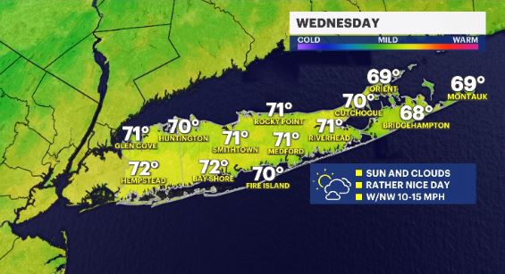
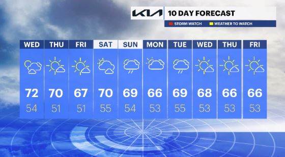
WEDNESDAY: Mostly sunny and mild with a breeze out of the southwest then out of the northwest, as weak front passes by. Highs: low 70s. Lows: mid 50s.
THURSDAY: *Pick of the week* Mainly sunny, with temps near average levels and a light breeze at times. Highs: low 70s to upper 60s. Lows: upper 40s to low 50s.
FRIDAY: Sunny then partly cloudy, with temps running a little cooler than average. Highs: upper 60s. Lows: low 50s.
SATURDAY: High level clouds at first then clouds thicken up through the day. Overall still dry and pleasant. Highs: low 70s. Lows: mid 50s.
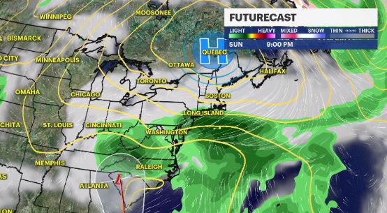
SUNDAY: Remnant moisture from IAN makes it's way up towards Long Island, with on and off rain chances, where sometimes it could be a little heavy. Highs: upper 60s. Lows: mid 50s.
EARLY NEXT WEEK: The remnant moisture from IAN will be lingering over our region, giving us rain chances for both Monday and Tuesday
More from News 12
0:17

2 people injured in Northern State Parkway crash
2:04

Near record cold tomorrow, rain and snow possible this week for Long Island
0:26

Pedestrian fatally struck by car in Stony Brook
1:11

Toddler fatally struck by vehicle in Mount Sinai
1:15

Carle Place restaurant reopens after $60K kitchen equipment theft
0:17
