More Stories
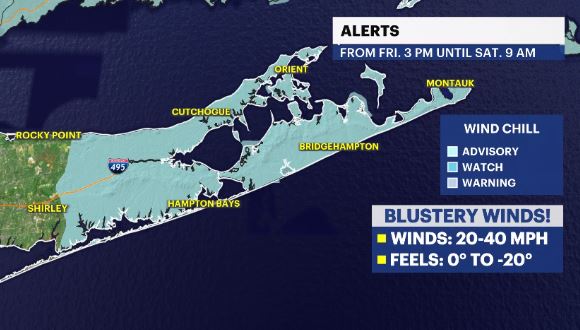
WHAT'S NEW: A Wind Chill Advisory is in effect from Friday at 3 p.m. until Saturday at 9 a.m. across eastern Suffolk County due to wind chills (feels-like temps) being around -10 to -20 degrees.
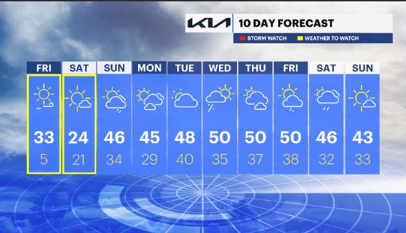
WHAT'S NEXT: This approaching "cold snap" will literally be just that. Temps will be rebounding from Saturday to Sunday and trend above average, again, for all of next week with an average high of 50 degrees.
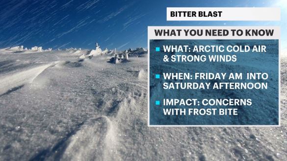
News 12 Storm Watch Team Meteorologist Addison Green says arctic cold air and strong winds move in to the area early Friday and last until Saturday afternoon.
OVERNIGHT: Partly cloudy with some light winds. Feels: Upper 10s. Lows: low to mid 20s.
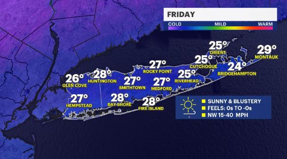
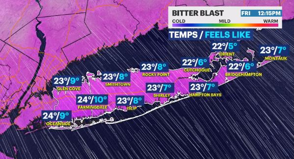
FRIDAY: BITTER BLAST – Mostly sunny skies with an arctic front moving through in the very early morning hours (where as it passes, it'll produce a brief snow shower). Temps will drop through the rest of the day with winds picking up.
Feels-like Temps will go from 5 at noon to -9 at 8 p.m.
Feels-like Temps will dip more overnight & will trend around -15 until 7 a.m. Saturday.
Highs: low to mid 30s. (this will occur very early Fri a.m.). Lows: mid 0s. (this will occur late FRI night)
SATURDAY: BITTER BLAST – Mainly sunny and COLD! Expect breezy winds through the morning hours with temps slowly trying to warm up.
Feels-like Temps will go from -9 at 8 a.m. to 5 at Noon and then slowly rise through the rest of the day and into the overnight hours into Sunday.
Highs: low to mid 20s. Low: upper 10s to low 20s.
SUNDAY: Partly cloudy to mostly cloudy skies with a small rain chance for the evening hours. Highs: mid 40s. Lows: mid 30s.
MONDAY: A mix of sun and clouds. Highs: low to mid 40s. Lows: upper 20s.
TUESDAY: Partly cloudy with above average temps. Highs: upper 40s. Lows: upper 30s to low 40s.
WEDNESDAY: Partly cloudy with a small chance for rain in the AM then breezy winds. Highs: upper 40s to low 50s. Lows: mid 30s.
THURSDAY: Sun & clouds with mild temps. Highs: upper 40s to low 50s. Lows: upper 30s.
FRIDAY: Mostly cloudy with scattered showers. Highs: upper 40s to low 50s. Lows: upper 30s.
SATURDAY: Partly cloudy with scattered showers. Highs: mid 40s. Lows: low 30s.
SUNDAY: Mostly sunny. Highs: low 40s. Lows: low 30s.
More from News 12
1:11

Toddler fatally struck by vehicle in Mount Sinai
2:02

Cold weekend on Long Island; arctic blast arrives next week
1:15

Carle Place restaurant reopens after $60K kitchen equipment theft
0:17

Carle Place man seriously injured in single-car Elwood crash
0:49

Remembering Liam Gleason: Funeral held for late Siena University men's lacrosse coach
2:18
