WHAT'S NEW: Tracking a cold front to come our way tonight, helping to drop us out of that "June feeling" that has been around recently, and back down to typical levels for this time of year.
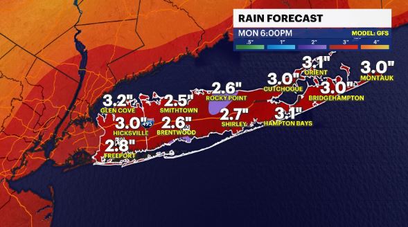
WHAT'S NEXT: Tropical moisture, from a system near the Bahamas, will come our way Friday into Saturday. A soaking few inches could be in store for Long Island as well as the chance for flooding.
TROPICS:
There are 2 disturbances being monitored by the National Hurricane Center.
NICOLE – The system is a sub-tropical storm, moving just north of the Bahamas. It will gradually move westward, towards Florida, and forecast to strengthen into a category 1 hurricane by Wednesday. It will weaken and move up the East Coast, bringing tropical rains by Friday/Saturday to Long Island.
A second system is a tropical wave in the Central Atlantic Ocean. It has a moderate (60%) chance of development in the next 5 days. It will pose no threat to anyone.
Storm Watch Team Meteorologist Addison Green says it's back to reality as traditional November temperature are set to return.
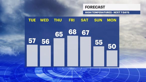
FORECAST:
OVERNIGHT: Mostly clear skies with breezy winds at times and a colder feeling in the air. Lows: mid 40s.
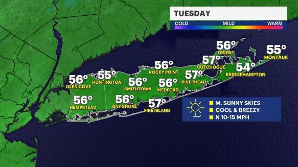
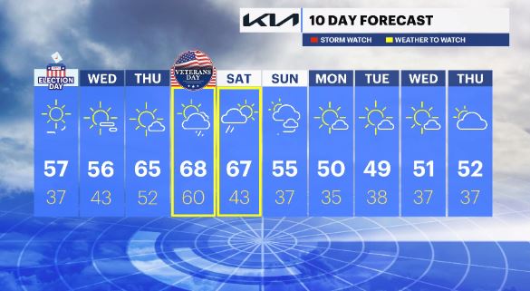
TUESDAY: ELECTION DAY – Mostly sunny, cooler, drier and breezy. Highs: upper 50s. Lows: upper 30s
WEDNESDAY: *Pick of the week* Sunny, cool and crisp with temps around seasonable levels for this time of year. Highs: mid to upper 50s. Lows: low 40s.
THURSDAY: A mix of sun and clouds, warmer but with more moisture moving in. Highs: mid 60s. Lows upper 40s to low 50s.
FRIDAY: VETERANS DAY – Mostly cloudy with scattered showers turning to heavier downpours as the day progresses. Heaviest rains arrive by the evening commute. Highs: mid 60s. Lows: upper 50s to 60.
SATURDAY: Heavy rains early on in the day, then drier conditions with breezy winds and cooler temps later. Highs: mid 60s. Lows: mid 40s.
SUNDAY: Partly cloudy & breezy with seasonable temps. Highs: mid 50s. Lows: upper 30s.
NEXT WEEK: Drier and cooler conditions.
More from News 12
2:30

BITTER BLAST: Icy morning ahead, as dangerous cold sweeps across Long Island this week
1:44

Suffolk police report dozens of crashes due to slick roadways
0:25

Dead geese in Huntington to be tested for bird flu
0:43

Woman seriously injured in 3-vehicle crash
0:34

Queens woman accused of kidnapping her 7-year-old child in Carle Place
0:46
