More Stories
A Mexican City that is rarely hit by hurricanes was given only 12 hours to prepare for the worst Pacific hurricane to ever make landfall in the country.
On Monday night, the National Hurricane Center in Miami issued a warning for residents to prepare for Tropical Storm Otis. The storm was expected to make landfall the next evening as a manageable tropical storm with winds under 75 mph. That was not what happened.
The storm hit a small pocket of warm water and very favorable atmospheric conditions and underwent "rapid intensification." By Tuesday morning, the storm reached hurricane strength and residents were told to prepare for the absolute worst-case scenario - a catastrophic major hurricane.
HOW RARE WAS OTIS?
Typically, coastal communities have days to prepare for storms like this - not hours. What makes Otis incredibly unusual is its location.
In the Eastern Pacific, hurricanes typically form off the Mexican coastline and move farther away from the country because the steering wind blows from east to west.
Since 1950, only 17 major hurricanes - including Otis - turned east and made landfall on the west coast of Mexico. This almost always happens in October when the steering flow changes with the change in season and also tends to be north of Acapulco.
Hurricane Patricia in 2015 is the only other Category 5 hurricane to make landfall on Mexico's west coast. It hit a more hurricane prone area up the coast, about 500 miles north of Acapulco.
Acapulco has only received one other direct hit from a hurricane since 1950, and it was a much weaker Category 1. The city rarely sees direct hits from hurricanes, but there are exceptions.
In 1997, flooding from Hurricane Pauline killed hundreds in Acapulco even though the storm made landfall much farther south. The mountains west of the city charged rain clouds with incredible amounts of moisture and also contributed to flash flooding.
HOW DID THE FORECAST GO SO WRONG?
Otis was a strong storm, but it was incredibly small in size. Hurricane force winds extended less than 30 miles from the center. These smaller hurricanes are more unpredictable because they can wind up very rapidly when conditions are favorable and dissipate as soon as conditions become unfavorable. They're also harder for models to see and there was less data going into the models because of its location away from historically hurricane active areas.
WHAT DOES NOVEMBER LOOK LIKE IN THE ATLANTIC?
Hurricane season is winding down for us in the Atlantic. Storms like Sandy, which made landfall on Oct. 29, 2012, are a reminder that the last weeks of the season can be active. Overall the later part of the season, November in particular, are quiet in our area.
Only three hurricanes have made landfall on the United States mainland after Nov. 1. The Southern Carribean, on the other hand, can remain very active while the rest of the Atlantic gets quiet.
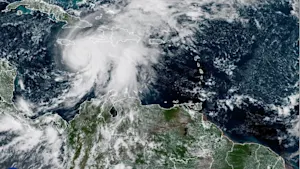
Just like Otis in the Pacific, Hurricane Eta in the Caribbean underwent "rapid intensification" before landfall in November 2020. Eta went from a Category 1 to a Category 5 in just 18 hours and then made landfall as a Category 4 in Nicaragua. Incredibly, Iota hit the same city just two weeks later as a Category 4 hurricane.
More from News 12

How to watch the last supermoon of the year tonight
2:12

Snow for some, rain for many: Everything you need to know about Tuesday’s coastal storm
1:40

Look up! The year’s third supermoon will grace the sky Wednesday night
0:34

Category 5 Hurricane Melissa brings flooding and catastrophic winds to Jamaica

Category 4 Hurricane Melissa threatens catastrophic flooding in Jamaica and Haiti
1:33
