STORM WATCH: Unsettled weather week brings lots of rain, flooding potential
Rainy weather is expected for most of the week, with some periods of dry, but cloudy conditions.
Share:
More Stories
1:46

Scattered rain overnight on Long Island; sunny skies Sunday afternoon
4h ago1:01

LIVE BLOG: News 12 weather updates
yesterday1:46
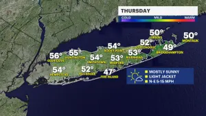
Mostly sunny and cooler Thursday before near seasonal temps return
2ds ago1:46
Chance for showers Wednesday; cooldown for the end of the workweek
4ds ago1:46
Sunny skies before rain moves in Wednesday
4ds ago1:46

Sunny and mild Monday for Long Island
5ds ago1:46
Scattered rain overnight on Long Island; sunny skies Sunday afternoon
4h ago1:01
LIVE BLOG: News 12 weather updates
yesterday1:46
Mostly sunny and cooler Thursday before near seasonal temps return
2ds ago1:46
Chance for showers Wednesday; cooldown for the end of the workweek
4ds ago1:46
Sunny skies before rain moves in Wednesday
4ds ago1:46
Sunny and mild Monday for Long Island
5ds agoRounds of rain this week with a series of systems are taking aim at New Jersey. Yes, there will be breaks in the wet weather but sunshine will not be at a premium until the end of the weekend.

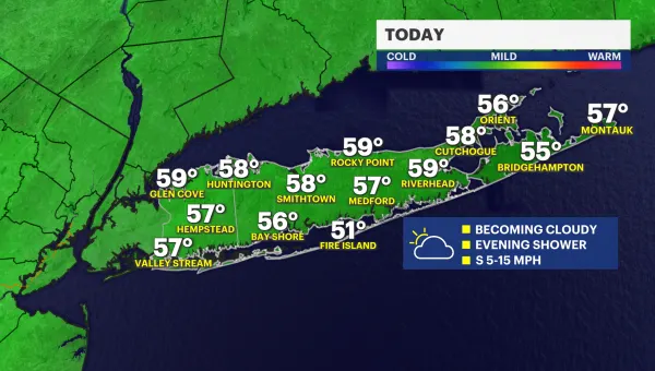
TONIGHT: Clouds collect and showers will start to slowly move in from the south and move to the north by daybreak. Lows around 42.

TUESDAY: On-and-off showers. The bulk of the rain we collect will happen just in time for the morning drive. Allow for extra time getting to work and school. High around 52.

TUESDAY NIGHT: The showers shut off temporarily. Lows around 44.
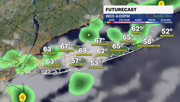
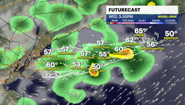
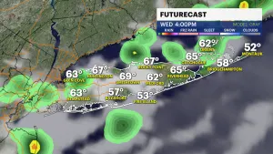
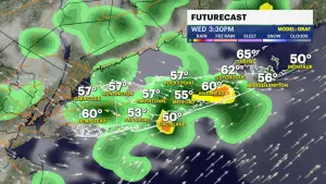
WEDNESDAY: The majority of the day is overcast. Temperatures will climb to the mid-50s. Late Wednesday afternoon the showers will pick back up again. This storm will carry a little more water than the last. Wednesday evening commute will be more affected.

THURSDAY: Showers linger into the morning then slow. Highs near 60 degrees.
FRIDAY: Best day of the week. Clouds and sun and dry. Highs around 53.
SATURDAY: Rainy and raw. This storm will bring a return to cooler and windier weather for the second half of the weekend.
SUNDAY: Daylight saving time begins at 2 a.m. Clocks move forward by one hour. Mostly cloudy but dry. Highs around 47.
Bottom line – the weather is – unsettled this week.

WHAT YOU NEED TO KNOW: Storm Watch Team Meteorologist Julian Seawright breaks down the details of the impending storm.