STORM WATCH: Rounds of drenching downpours bring a flood threat to Long Island today
Rounds of gusty, heavy rain are expected through the early afternoon and evening. Watch for flash flooding in your area through the day.
More Stories


WHAT YOU NEED TO KNOW:
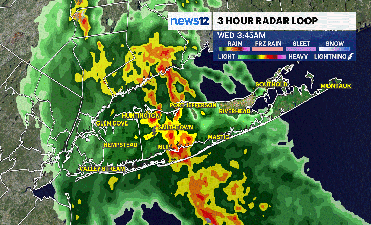
Pockets of heavy rain this morning
Medium flash flood risk for Nassau and Western Suffolk County today
Wind-driven thunderstorms today, with an isolated severe thunderstorm risk with damaging winds possible.
Heaviest rainfall will be this morning and early in the afternoon
Rain will clear out by the evening
Drier weather on Tuesday
A FLOOD ADVISORY IS IN EFFECT for Nassau and Suffolk counties. Heavy rain is causing minor flooding until 10:30 a.m. Avoid flooded roads and never drive through water. Turn around, don’t drown
Heavy rain is causing rapid flooding of roads, small streams, and low-lying areas. Water levels may rise quickly and become dangerous. If you are in the warned area, avoid flooded roadways and never attempt to drive through standing or moving water. Just a small amount of flood water can sweep a vehicle away or render it immobile. Turn around, don’t drown.
Move to higher ground if flooding develops and stay tuned for updates as the situation evolves.

FORECAST:
A drenched morning from heavy rainfall will lead to a very wet afternoon. We are tracking storms for the day that pose a few threats for Long Island. One being a medium flash flood risk for Nassau and Western Suffolk County, and a marginal risk for an isolated severe thunderstorm that could produce damaging wind gusts up to 50 mph.
The severe weather threat is low for the day, but expect the biggest impacts to come from the drenching downpours this morning and early this afternoon. The storms are expected to end around the evening commute and early tonight. The skies will gradually clear, and it will be less humid overnight into Tuesday.
For today, have the rain gear ready to go and expect widespread ponding and puddles in your neighborhood.
The rest of the week is mainly dry, but there are some chances for rain showers or a couple of thunderstorms midweek.


