Record-breaking warmth heading to New Jersey again to end the week
The excessive warmth will continue for one more day before showers and isolated thunderstorms bring back some normalcy to the forecast.
More Stories


After a winter season of bitter cold and what seemed like endless weekend snow events, the state got another taste of summer this afternoon.
It was a record-breaking afternoon around New Jersey. Sussex Airport shattered the 80-degree record set in 2003, with an afternoon high of 85 degrees. Trenton Airport peaked at 88 degrees, breaking the record of 87 set back in 1994 and Atlantic City tied the record set back in 1967 with 90 degrees.
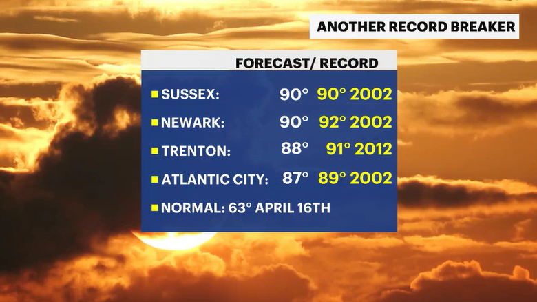
Will we see another record breaker tomorrow? It's looking more likely that we will.
Temperatures will be very warm tonight - comfortably so. Look for nighttime lows to be in the low to upper 60s. The lack of mugginess is what helps keep the weather bearable. It's possible, unlikely, but can't be ruled out either, that an isolated thunderstorm could quickly cross the northernmost parts of New Jersey.
Thursday will feature another round of above-average warmth. Most neighborhoods will peak again in the upper 80s. A few other towns will be warmer in the low 90s. The heat will likely peak at record levels.
Scattered showers on Friday will bring down the temperatures. We'll go from the 80s and 90s back to the low 70s. Cooler than the last few days, but still warmer than where it should be for this time of year. The normal high for mid-April is 63 degrees.