Could the Atlantic have NO hurricanes for the first time on record?
The 2026 Atlantic Hurricane Season is on track to be the quietest on record, but will it stay that way?
More Stories


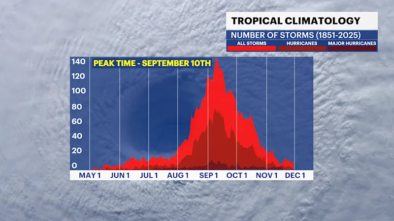
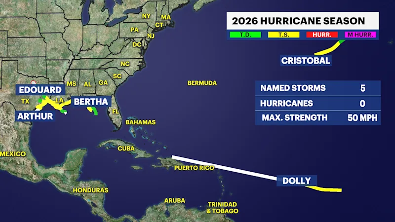
We haven't talked much about hurricanes this year, because there haven't been any in the Atlantic and that's very unusual. On average, the first hurricane of the season forms around July 27, but there hasn't been a single hurricane in the Atlantic Basin so far this year.
We are now entering the week that leads up to the average peek of the Atlantic Hurricane Season without a single hurricane. The National Hurricane Center does not expect any tropical development in the next seven days which means it is very possible that when the first hurricane of the season develops, it will be the latest since the start of the satellite era.
As of September 3, the Atlantic has produced five named storms but no hurricanes. Only seven seasons since 1966 have waited until September to produce their first hurricane. The latest first hurricane in the modern record formed on September 11, a date reached by Hurricane Gustav in 2002 and Hurricane Humberto in 2013.
The record for fewest hurricanes since 1966 is two, a record set in both 1982 and 2013. The least active Atlantic season of the satellite era overall was 1983, which produced just four named storms and an ACE of about 17.
El Nino shifts activity to the Pacific.
While the Atlantic has struggled, the eastern and central Pacific have been extraordinarily active. As of the morning of September 3rd, there are three hurricanes in the Pacific. Hurricane Lowell reached Category 5 intensity earlier this week and is expected to remain a major hurricane for at least the next 5 days. After that, the hurricane will threaten the western Hawaiian islands and could make a close brush with Kauai. Nearby, Hurricane Karina remains a major hurricane and category 1 Hurricane Marie gradually strengthens.
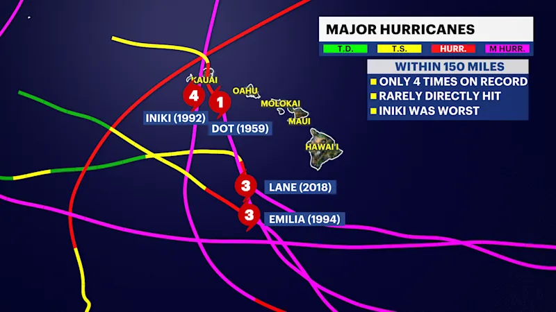
Hawaii has only had 4 major hurricanes come within 150 miles of the island on record. Hurricane Lala was a category 1 hurricane at its closest approach earlier this season, but Hurricane Lowell could approach as a category 3, which would make it only the 5th major hurricane on record to come that close to the major islands.
The lack of storms in the Atlantic and the incredibly active Pacific can all be linked directly to El Nino. El Nino describes abnormally warm ocean temperatures in the tropical Pacific. While the warm ocean waters creates a favorable environment for tropical development there, it produces strong vertical wind shear downstream in the Atlantic, tearing up storms before they develop.
Accumulated Tropical Cyclone Energy is very high globally.
One of the best ways to measure the overall strength of a hurricane season is Accumulated Cyclone Energy, or ACE, and the number globally is very high.
ACE incorporates the intensity and duration of a storm. It's calculated every six hours, by squaring the maximum sustained wind of a named tropical cyclone is squared and adding to the seasonal total. Only systems with wind speeds of at least 39 mph are calculated. That means a long-lived, powerful hurricane contributes far more ACE than a weak storm that lasts only a day or two.
Colorado State University's real-time tropical statistics has the Atlantic at only about 4 ACE units as of September 3 which is the lowest on record. The average ACE is around 44 units for this point in the year.
However, the Accumulated Cyclone Energy (ACE) is considerably stronger in the Pacific basin. Globally, Earth has accumulated 522 ACE units so far this season (as of early Sep 3) which is about 120% above average. So globally, tropical cyclone energy is actually above normal. The Atlantic is the major outlier.
Atlantic Hurricane Season could still wake up.
Much of the Atlantic basin's ocean temperatures warmer than normal and that will likely remain the case. However, it's likely that wind shear will limit hurricane growth in the Main Development Region in the Central Atlantic. The Gulf of Mexico, Caribbean and western Atlantic could become breeding grounds for tropical storms or hurricanes later this month into October creating short lived & strong storms that are at greater risk of producing landfall.
However, El Nino is strengthening so it will become even more influential in reducing hurricane activity in the later part of the season, so while we still have a few more weeks of potential hurricane development, the risk for strong hurricanes this season remains much lower than usual.