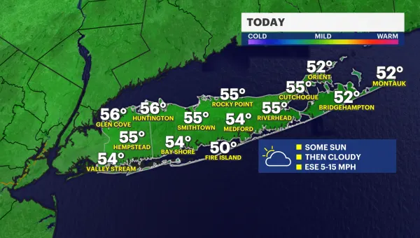
Sunshine Saturday before clouds roll in late afternoon Sunday
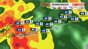
Storm Watch Meteorologist Addison Green says Saturday is the pick of the weekend with sunny skies and temperatures in the 80s. Sunday starts off sunny before clouds roll in by the afternoon.
News 12 Staff
•
Jul 29, 2022, 11:27 AM
•
Updated 629 days ago
Share:
More Stories
2:05

Mostly cloudy skies and cool conditions on Long Island
3h ago1:01

LIVE BLOG: News 12 weather updates
5h ago2:03
STORM WATCH: Periods of heavy rain, thunderstorms possible to close out the workweek
8ds ago
Guide: Tips to prevent fires during red flag warning
10ds ago2:03
Warmup for the next few days before rain moves in to end the workweek
10ds ago1:52

Long Islanders take part in solar eclipse viewing parties at Jones Beach, Cradle of Aviation
10ds ago2:05
Mostly cloudy skies and cool conditions on Long Island
3h ago1:01
LIVE BLOG: News 12 weather updates
5h ago2:03
STORM WATCH: Periods of heavy rain, thunderstorms possible to close out the workweek
8ds agoGuide: Tips to prevent fires during red flag warning
10ds ago2:03
Warmup for the next few days before rain moves in to end the workweek
10ds ago1:52
Long Islanders take part in solar eclipse viewing parties at Jones Beach, Cradle of Aviation
10ds agoNOW: Scattered showers and pockets of heavy rain taper off overnight.
NEXT: After a nearly picture-perfect end to July, we move into August with hazy, hot and humid air returning!
Storm Watch Meteorologist Addison Green says Saturday is the pick of the weekend with sunny skies and temperatures in the 80s. Sunday starts off sunny before clouds roll in by the afternoon.
FORECAST:
OVERNIGHT: Scattered showers and misty conditions with the potential of some light fog by daybreak along the coast. The cloud cover will thin out by sunrise on Saturday with a more comfortable, less humid feeling in the air. Overnight lows in the upper-60s.
SATURDAY: *Pick of the week* Lots of sunshine with comfortable levels of humidity and a light, northerly breeze. Highs in the mid-80s. Lows in the mid-60s.
SUNDAY: After a sunny start, cloud cover slowly moves in for the afternoon hours, but showers are not expected until after sunset. Highs in the upper-80s. Lows in the upper-60s to low-70s.
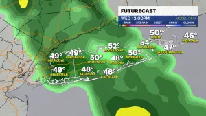
MONDAY: Hello August! Mix skies of sun and clouds with a few pockets of showers along the way. Highs in the mid-80s. Lows in the low-70s.
REST OF NEXT WEEK: Getting hot, hot, hot! The average high is 83 for this time of the year, and we'll be in the upper-80s for Tuesday and then the 90s for the rest of the week with feels-like temps in the upper-90s or even over 100. Likely to see another round of heat advisories and a potential heat wave coming around for at least three to possibly four days. There will be a spot storm chance for Tuesday and Friday.